vFri, 09 Mar
Friday saw a new eruption of the Bezymianny volcano on the Kamchatka Peninsula in the Russian Far East. 
© EPA
Bezymianny volcano
Bezymianny volcano
One of the most active volcanoes in the world, Bezymianny is located 350 kilometers northeast of the city of Petropavlovsk-Kamchatsky.
During its most powerful eruption in 1956, the 2,800-meter volcano ejected about three cubic kilometers of volcanic debris in a very short time.
-------------------------------------------------------------------------------------------------------------------------------------
Cleveland volcano
Fri, 09 Mar

A restless Aleutian volcano exploded Wednesday night and may have blown off a slow-growing lava dome that was building for months in its summit crater, volcanologists say. Cleveland Volcano, 940 miles southwest of Anchorage, probably burped up a small amount of ash - a potential hazard to trans-oceanic air travel - but the ash did not appear to reach above 20,000 feet, said Steve McNutt, a researcher with the Alaska Volcano Observatory.
Because of its remoteness, harsh weather in the area and budget constraints, Cleveland Volcano does not have instruments on its flanks. As a result, scientists cannot listen to its inner rumblings. But distant seismometers and specialized microphones detected the explosion about 7 p.m. Wednesday, according to the observatory. The explosion caused a displacement of air and an airwave traveled out from the volcano at the speed of sound, McNutt said. Instruments at volcanoes 60 and 90 miles away detected the explosion several minutes after it occurred, he said.
Clouds on Wednesday and today prevented clear satellite views, so scientists are not sure exactly how much ash may have shot out of the 5,676-foot volcano, which makes up the western half of Chuginadak Island. "It is the Aleutians in winter, after all,' McNutt said. Either way, the researchers do not think the volcano poses an immediate threat to planes. McNutt thinks the explosion blasted away a lava dome building inside the volcano's summit crater. As the thick, pasty molten rock flows slowly into the crater, it piles up and plugs gas vents, he explained. An explosion can occur when the gas builds up enough pressure, McNutt said.
----------------------------------------------------------------------------------------------------------------------------------------
Fri, 09 Mar
Iliamna volcano experienced several episodes of increased earthquake activity over the last three months, according to a news release issued Wednesday by Alaska Volcano Observatory officials. One of the episodes is currently ongoing and is characterized by numerous small earthquakes.

The increase in activity may be related to movement of magma at depth and additional observations, including an airborne gas sampling and observation flight, are being planned to help constrain this interpretation, according to the release. A similar but longer episode of increased earthquake activity occurred from September 1996 to February 1997 and likely was related to the intrusion of new magma at depth. That incident did not result in an eruption.
The AVO reports there have been no known historical eruptions of Iliamna. "AVO will continue to observe Iliamna carefully and will report on new observations and interpretations as warranted," the release states. The volcano's alert level remains at normal with the aviation color code at green.

© M. Scott Moon
Mount Iliamna, pictured several years ago, is showing unrest.
Mount Iliamna, pictured several years ago, is showing unrest.
The AVO reports there have been no known historical eruptions of Iliamna. "AVO will continue to observe Iliamna carefully and will report on new observations and interpretations as warranted," the release states. The volcano's alert level remains at normal with the aviation color code at green.
-------------------------------------------------------------------------------------------------------------------------
Volcanic activity increases at Japan’s Sakurajima volcano
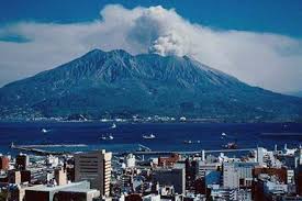 March 8, 2012 – JAPAN – Sakurajima volcano appears to be at higher levels of activity, as the last week has seen an increased average number and size of eruptions. According to the latest USGS / Smithsonian report “explosions during the past week “often” produced plumes that rose to altitudes of 1.2-3 km (4,000-10,000 ft) and drifted NW, E, and SE.” Many observations of ash plumes originate of analysis of satellite data and dedicated Volcanic Ash Advisory Centers (VAAC) around the world monitor them and transmit real-time information about hazardous ash plumes to aircraft and air traffic control centers. Such reports are often complemented by direct observations from pilots passing nearby. Ash plumes from Sakurajima were observed by pilots on 5 and 6 March, the latter drifting SE at an altitude of 2.4 km (8,000 ft). Sakurajima volcano in southern Kyushu, Japan, is one of the few volcanoes in the world with near persistent activity and typically produces 1-2 strombolian to vulcanian-style explosions per day. –Volcano Discovery
http://theextinctionprotocol.wordpress.com/2012/03/08/volcanic-activity-increases-at-japans-sakurajima-volcano/
---------------------------------------------------------------------------------------------------------------------------------------
Magma Plume: Mt. Etna volcano rocked by third eruption in 2012

March 5, 2012 – ITALY - Etna just keeps on rolling. The Italian volcano had its third paroxysm of 2012 (see above) on March 4 and first since early February. This new eruption was a short event that was preceded by 18 days worth of small strombolian activity. The event may have been only ~2 hours, but it produced some spectacular explosions, aiding in some part by interaction with snow and a pyroclastic flow was spotted as well. Osservatario Etneo reported that even a small lahar was produced during this paroxysm as a result of volcanic material mixing with snow. Air traffic around Sicily was not affected by this paroxysm. –Wired
http://theextinctionprotocol.wordpress.com/2012/03/05/magma-plume-mt-etna-volcano-rocked-by-third-eruption-in-2012/
-----------------------------------------------------------------------------------------------
Rise in activity reported at Ecuador’s Tungurahua volcano
 March 4, 2012 – ECUADOR – The Tungurahua volcano increased its activity level at 18:30 on Saturday. According to the technicians of the Observatory of the Geophysical Institute, this is characterized by the explosive ejection of incandescent rocks with additional steam and ash. Moreover, the intensity of the bellows rose relative to those detected at 14:20 on the start of this new eruptive process. Jorge Bustillos, a volcanologist, said the expulsion of the material reaches 500 meters above the crater and the vapor cloud 800. “The activity is Strombolian type, this is identified by the output of lava, steam and ash.” The volcano has been rattled by no less than four large explosions reports Volcano Discovery. Lookouts of the colossus said there was a fall of volcanic dust cam in communities Puela, Chonglontus and El Manzano, in Chimborazo. The cloudy nights have impeded direct observation of the giant crater. Serafin Medina, a resident of Palictahua said that since the late bellows have been emitted from the volcano, activity at the volcano has increased. “We listen to what they say the technicians of the Geophysical Institute.” –El Comerico translated
http://theextinctionprotocol.wordpress.com/2012/03/04/rise-in-activity-reported-at-ecuadors-tungurahua-volcano/
------------------------------------------------------------------------------------------
Moderate ash explosions reported at Guatemala’s Santa Maria volcano
 March 2, 2012 – GUATEMALA – Santa Maria/Santiaguito volcano in Guatemala has been displaying a slightly elevated state of activity in recent days. INSIVUMEH reports moderate explosions about every 15 minutes that eject plumes of gray ash tot 600 and 800 meters above the crater, and producing an ash plume drifting to the west and SW until dissipating at about 15 km distance. Light ash falls from these eruptions frequently occur in the villages San Marcos, Buena Vista and Palajunoj and the El Faro, Florida, and Monte Claro Fincas. Crater glow at the summit of the lava dome is well visible at night, and a blocky lava flow with constant avalanches of blocks rolling down to tits base continues to be active, raising secondary ash plumes. –Volcano Discovery
http://theextinctionprotocol.wordpress.com/2012/03/02/moderate-ash-explosions-reported-at-guatemalas-santa-maria-volcano/
-------------------------------------------------------------------------------------------------
Slight rise of magma at Boliva’s potential super-volcano, Uturuncu but no signs of an immediate eruption

March 2, 2012 – BOLIVIA – The San Calixto Observatory director of La Paz, Estela Minaya confirmed that there is a small rise of magma (molten rock in the form of lava and gases) from the volcano Uturuncu, however, but immediately rule out a possible eruption. Minaya told the Red Erbol said now one of the purposes of the Observatory is to trace the progression of the volcano and to determine how high and fast magma is rising inside the volcano. “Then, (known) that the molten material begins to rise and generates what is seen as a strain at the surface. Studying this method indicates what kind of deformation and “growth,” the volcano is experiencing. Right now, indication there is a slight rise but the magma is rising at a very low speed. Now that this ‘growth’ isn’t very large and can’t generate a volcanic eruption,” he said. He noted that this work takes place two years ago with the interferometer system and the last eruption in Uturuncu would have registered more than 1.6 million years or so. A week ago, was reported in boliviaprensa.com international scientists are studying the changes introduced Uturuncu volcano, since satellite measurements show that the mountain has been growing at a rate of 1.3 centimeters per year over the past two decades. -Erbol translated
-------------------------------------------------------------------------------------------------
Volcanic activity increasing at Indonesia’s Semeru volcano
 March 2, 2012 – JAKARTA – Volcanic activities in Indonesia’s Mount Semeru keep increasing with 38 tremors on Thursday from around 28 everyday and its danger status remains at level III, an official told Xinhua. Dr. Surono, head of Vulcanology and Geological Hazard Mitigation of Geology Agency (PVMBG) said that the volcano keeps erupting every day, forming volcanic dome and emitting smoke. “Tremor occurs every 15-30 minutes,” said Surono. However, he said that the agency has not yet urged people living surrounding the volcano to evacuate. According to local media, some people in the area are worried of sudden eruption that could destroy their villages following the increasing volcanic activities. Mount Semerun, the highest one in Java Island with height of 3, 676 meters, is one of the most active volcanoes in Indonesia. -EPD
----------------------------------------------------------------------------------------------------------------------------------------
Indonesia’s Mount Merapi volcano shaken by twin eruptions
 February 29, 2012 – BUKITTINGGI, Indonesia (BNO NEWS) —Mount Marapi, a volcano located in the Indonesian province of West Sumatra, briefly erupted on early Wednesday morning, officials said. It comes after activity was also reported at the volcano in August 2011. The 2,891-meter (9,485 feet) tall volcano, which is located near the cities and town of Bukittinggi, Padang Panjang and Batusangkar in West Sumatra, began erupting at around 7:30 a.m. local time on Wednesday, according to the Antara news agency. Marapi’s initial eruption lasted around fifteen minutes and spewed out volcanic ashes which reached some 200 meters (656 feet) to the south from its crater. A second eruption took place moments later, lasting about ten minutes and bringing thick white smoke about 100 meters (328 feet) up. Suparmo of the Volcanological and Geological Disaster Mitigation Center (PVMBG) in Bukittinggi told the Antara news agency that Mount Marapi will remain at a Level II alert status as it is still prone to eruptions and other kinds of activity. In addition, he called on locals to remain alert. Since August 2011, Mount Marapi, the most active volcano on the island of Sumatra, has shown increased volcanic activity. The PVMBG has installed seismometers and digital analogs at an altitude of 2,000 meters (6.560 feet) at Nagari Batu Palano and at an altitude of 1,500 meters (4,920 feet) at Nagari Lasi in order to monitor the activity. Dozens of active volcanoes in Indonesia are part of the Pacific Ring of Fire, known for frequent earthquakes and volcanic eruptions. One of Indonesia’s most active volcanoes is Mount Merapi, which is located on the island of Java near Jogjakarta, the country’s second-most visited area after Bali. Last year, more than 300 people were killed in a series of eruptions between October and November which also displaced over 300,000 people. – Channel 6 News
----------------------------------------------------------------------------------------------------------------------------------------
Mexico’s Popocatepetl volcano rumbles with 16 low intensity emissions – alert level, Phase 2, yellow
 February 28, 2012 – MEXICO (Notimex) – The National Center for Disaster Prevention (Cenapred) reported that in the last 24 hours, the Popocatepetl volcano registered 16 emissions of low intensity, accompanied by emissions of water vapor, ash, and gas. The body of the Interior Ministry said in a statement that the largest emissions occurred yesterday at 14:50 and 17:12 hours during the night glow was observed on the volcano, while the rest of the monitoring parameters remain approximately unchanged. He said, at the time of the report, a slight emission of water vapor and gas was flashing from the volcano. The volcanic alert remains in Phase 2 yellow. The Ministry said there were moderate exhalations, some with ash emissions, sporadic bursts of low to moderate probability of emission of incandescent fragments within walking distance of the crater and incandescent light in the observable crater overnight. The Cenapred explained that a security parameter remains in a 12 kilometer radius of the volcano, so staying in that area is not permitted and controlled traffic is maintained between Santiago and San Pedro Nexapa Xalitzintla via Paso de Cortes. He called the Civil Protection authorities to maintain preventive procedures, according to their operational plans and to keep people alert to the official information that is released. -Yucatan translated
-------------------------------------------------------------------------------------------------
Costa Rica’s Rincón de la Vieja volcano awakens with new activity
 February 27, 2012 – COSTA RICA – It has been almost exactly 14 years since the last eruptive period for Rincón de la Vieja in Costa Rica, but it looks like the volcano might be awakening from its break. Last Thursday (Feb. 22), the volcano experienced two small explosions in the early morning. Seismic records suggest the volcano also had small explosions on Feb. 19 and 20, according to the OVSICORI report for Feb. 25 (PDF). None of the explosions caused any damage to anything near the volcano and there are no reports of ash fall other than in the crater itself. These explosions are very similar in style to the September 2011 explosions that were like phreatic in nature — that is, not new magma but superheated water generated the explosions. Of course, it is likely that new magma intruding the volcano is the heat source for the water, but these explosions could precede a new magmatic eruption by months or years (or lead to nothing at all). The volcano sits within a national park in Costa Rica and after these explosions; the National Emergency Commission has declared the crater area off-limits to visitors. The last major eruption from Rincón de la Vieja was in 1966, when it produced at VEI 3 event that generated pyroclastic flows. –Wired
http://theextinctionprotocol.wordpress.com/2012/02/27/costa-ricas-rincon-de-la-vieja-volcano-awakens-with-new-activity/
-------------------------------------------------------------------------------------------------
Another volcano awakening? Rise in activity at Colombia’s dreaded Nevado del Ruiz volcano
 February 26, 2012 – COLOMBIA - From 12:30 hours local time on February 23, a new increase in seismic activity of the Nevado del Ruiz volcano began, characterized by the occurrence of shallow earthquakes associated with fluid movements and fracturing of rock. INGEOMINAS also measured increased SO2 emissions and some changes in strain measurements. So far, the energy level of this increase is low compared with previous episodes of unrest, but small eruptions in the near future are possible. On November 13, 1985, a small eruption from Nevado produced an enormous lahar that buried and destroyed the town of Armero in Tolima, causing an estimated 25,000 deaths. This event later became known as the Armero tragedy—the deadliest lahar in recorded history. The seismicity is located under the active Arenas crater at depths ranging between 0.5 and 3 km, and reached a maximum recorded magnitude of 1.4 on the Richter scale. The volcano last erupted in 1994. –Volcano Discovery
------------------------------------------------------------------------------------------------------------------------------------------------------------------------
Malaysian island region inundated with massive volcanic mud flow

February 24, 2012 – Borneo, MALAYSIA - Volcanic mud has been spewing at least twice to three times more actively than normal since last week. This has created an overflow of the sulphuric substance that has spread over an area as big as a football field. Apart from excited guests at the nearby Tabin Wildlife Resort, the number of wild animals, too, appears to have increased at the mud pool. Volcanic mud is believed to contain curative properties with iodine, bromine, calcium and magnesium. According to Wikipedia, since the mud solution has no significant toxic substance, it is used as a curative agent for mud baths at spas. Mud baths have existed for thousands of years and can now be found in high-end spas in many countries of the world. The mineral-rich pool serves as a salt lick for animals at the Tabin Wildlife Reserve, including endangered species such as the Sumatran rhino and the pygmy elephants. On a normal day, mud would continuously spew from within the pool and dry up in a day or two once it spills over. Last week, however, according to a wildlife ranger who declined to be named, it was rather active judging by the overflow. “Earlier last week, we saw it to be more active and when we returned a few days later, the mud had flowed over a big area,” he said, adding that people and animals had suddenly started coming to the reserve in droves. Nestled amid 120,500ha of dipterocarp rainforest and tropical plants, some of which are rich in medicinal and therapeutic values, the reserve is a popular haunt for bird watchers and wildlife enthusiasts. Besides the rhinoceroses and elephants, it is also home to the clouded leopard, sambar deer, exotic wild birds and the orangutan. –Strait Times
--------------------------------------------------------------------------------------------------------------------------------------------------------------------------
Magma Plume: Is Hawaii’s most active volcano about to enter a more violent phase?
 February 24, 2012 – HAWAII - A magnitude 4.1 earthquake rattled the summit of Kilauea tonight, continuing a swarm of small tremors that shook the region Wednesday. The latest quake, which hit at 9:11 p.m., was the strongest of the swarm so far and was centered 5 miles west of Volcano at a depth of 3.2 miles, according to the U.S. Geological Survey. The shaking was felt up to 75 miles away in Waikoloa, according to the USGS. A flurry of small temblors were recorded after the 4.1 magnitude quake. On Wednesday, USGS officials said a swarm of more than 60 small, shallow quakes — the strongest measuring magnitude 3.2 — were recorded in Hawaii Volcanoes National Park. Swarms of small quakes have been recorded before in the area and sometimes signal a shift in the eruption of the east rift of the volcano, they said. –Star Adviser
--------------------------------------------------------------------------------------------------------------------------------------------------------------------------
Aleutian Island’s Kanaga volcano awakens- first eruption in 17 years
 February 20, 2012 – ALASKA - The remote Kanaga stratovolcano in the Aleutian Islands might have begun erupting, the Alaska Volcano Observatory (AVO) reports. A possible ash cloud about 39 km (24 mi) NE of the volcano, likely from weak explosive activity, was detected on satellite imagery, and volcanic tremor was detected under the volcano from 15:23-15:27 UTC (6:23 AM AKST) on 18 February, followed by numerous small events for about an hour at Kanaga Volcano. AVO has placed the volcano at Aviation Color Code YELLOW. “This new unrest indicates a possibility for sudden explosions of ash to occur at any time, and ash clouds exceeding 20,000 feet above sea level may develop. If a large, explosive, ash-producing event occurs, the local seismic network, satellite ash alarms, infrasound, and volcanic lightning will alert AVO to the new activity.” Kanaga Volcano occupies the northern corner of Kanaga Island, one of the most southerly members of the central Aleutian chain. It is a symmetric composite cone 1307 m high and 4.8 km in diameter at sea level, built of interbedded basaltic and andesitic lava flows, scoria layers, and pyroclastic rocks. Kanaga Volcano last erupted 1994-1995 when observed eruptive plumes were relatively dilute, rising to altitudes of less than 3 km (9,840 ft) and dropping ash onto the flanks of the volcano. At least two significant ash plumes were recorded over the course of this eruption: the first, to ~7.5 km (24,600 ft) occurred on February 21, 1995 and the second on August 18, 1995, when an eruption cloud reached ~4.5 km (14,760 ft). A light dusting of ash fell on the community of Adak and air traffic was disrupted due to continuing low-level activity and cloudy conditions which prevented visual approaches to the Adak air field. –Volcano Discovery
http://theextinctionprotocol.wordpress.com/2012/02/20/aleutian-islands-kanaga-volcano-awakens-first-eruption-in-17-years/
-------------------------------------------------------------------------------------------------
Japan’s Mt. Fuji volcano awakens after 300 years- increased risk of an eruption warns scientist
 February 19, 2012 – JAPAN – Reports are appearing about unrest and signs of a possible awakening of Mt Fuji volcano in Japan. According to a report which includes an unclear photo of the area, a row of new craters, the largest 50 m in diameter, has appeared on the eastern flank of the volcano at 2200 m elevation. Steam was observed erupting from these vents. The observation joins other signs suggesting a gradual reawakening: A swarm of earthquakes including 4 of magnitude 5 have occurred northeast of Mt Fuji on and after 28 January. An earlier 6.4M quake occurred under the volcano on 15 March 2011. The report also mentions increased activity from a fumarole vent at 1500 m elevation and hot spring areas at the eastern flank observed since 2003. These locations seem to be aligned geographically, and are probably connected. Dr. Masaaki Kimura of Ryukyu University is quoted to admit that there is an increased risk of an eruption on the eastern flank and that the status of the volcano should be closely monitored. Mt. Fuji last erupted in 1707, some 305 years ago. –Volcano Discovery
----------------------------------------------------------------------------------------------------------------------------------------
Magma plume: Volcanologists monitor swarm of new tremors under El Hierro Island
 February 16, 2012 – CANARY ISLANDS - The submarine eruption south of El Hierro Island could be in a process of change: While visible activity on the sea surface above the vent, as well as harmonic tremor signal (thought to be more or less proportional to erupting magma flux) have nearly ceased, the number of earthquakes under the island has increased sharply since yesterday. On 15 February, more than 20 quakes were measured. Most of the earthquakes were very small, well below magnitude 2, and were clustered beneath the NW and SW sectors of the island at depths of around 10 km. There is no conclusive interpretation of this measurement. A possible (and usually assumed) scenario is that rising new magma from the mantle reservoir is creating new intrusions and rupturing rock to create pathways in the crust under El Hierro, not using the same paths as until now. That would explain why less magma is currently being erupted at the current vent(s). In that scenario, the eruption will continue, perhaps even from a different vent and an increase in magma output is going to be expected any time soon. However, this is speculation. The earthquakes could as well be related to some other (known or unknown) process, e.g. gravity-induced adjustments that respond to pressure changes and occur within previously ruptured areas of the crust beneath the island. The next days or weeks will show what happens next. –Volcano Discovery
http://theextinctionprotocol.wordpress.com/2012/02/16/magma-plume-volcanologists-monitor-swarm-of-new-tremors-under-el-hierro-island/
-------------------------------------------------------------------------------------------------
Nine weak ash eruptions reported at Guatemala’s Fuego volcano
 February 14, 2012 – GUATEMALA – Weak ash explosions continue at Fuego volcano. INSIVUMEH reported for 13 February that 9 eruptions were counted; producing plumes up to 500 m high and occasional rumbling noises. A steam plume is rising constantly about 100 m from the crater. The ash drifted 8 miles WSW. The new lava flow on the southwest flank in the direction of the Taniluya ravine is still active and about 200 m long. Blocks that detach from its front form small block avalanches that reach the vegetation. –Volcano Discovery
--------------------------------------------------------------------------------------------------------------------------------------------------------------------------
Alert status raised on Indonesia’s Galunggung volcano
 February 13, 2012 – INDONESIA – The alert status of Galunggung volcano in West Java, Indonesia, was raised today due to an increase of its water temperature and a change in color. Discoloration of the Crater Lake had started to be noticed in September 2011, but the changes have increased recently. According to the local volcanologists monitoring the volcano, the whole lake is now of muddy khaki color. In addition to the color change which could be caused by an increase of lake fumarole activity, an steep sudden increase by 13°C of the lake water temperature was detected, based on measurements taken on and before 5 February when it was at normal 27°C, and on 8 Feb, when it was 40°C warm. Most fish in the lake have died and occasionally dead birds are found at the shore. No other signs of a possible volcanic awakening were detected at the moment. The ph level of the water is still at normal levels 7-8, and there is no sulfur smell. Also, no significant seismic activity has been detected. Nevertheless, PVMBG has now placed the volcano at alert level 2 (“watch”, on a scale of 1-4) and recommends to stay away at least 500 m from the lake shore. The last eruptions of Galunggnug were a small phreatic explosion in 1984, and the major destructive eruption in 1982-83, which produced violent explosions with ash columns reaching 20 km height, pyroclastic flows and large lahars. The eruption destroyed an older lava lake, killed many people and displaced up to 35,000. The eruption is infamous for the aircraft accident on 24 June 1982: a British Airways Boeing 474 with 262 people on board flew through the ash plume and had to make an emergency descent after the ash caused all 4 engines to fail; fortunately, the plane could land safely. The present-day Crater Lake (Danau kawah Galunggung) has a diameter of 1000 m and is 11 m deep and contains a volume of about 8 million m3 of water. In the middle of the lake, a small 250 x 165 m diameter scoria cone which was produced during the final staged of the 1982-83 eruption rises to 30 m elevation. A main hazard of the volcano is phreatic and phreatomagmatic eruptions capable of draining the lake and producing mud flows. –Volcano Discovery
----------------------------------------------------------------------------------------------------------------------------
Philippines Mt. Kanlaon volcano summit closed after large cracks found near crater
 February 10, 2012 – BACOLOD CITY, Philippines – Mount Kanlaon, an active volcano, has been declared temporarily closed to mountaineers after large cracks believed to have been caused by Monday’s 6.9-magnitude earthquake were observed at its crater and land surfaces, a local official said Friday. Kanlaon straddles the provinces of Negros Occidental and Negros Oriental. It has an elevation of 2,435 meters (7,989 feet) and a base diameter of 30 kilometers. Cecil Cañada, Mt. Kanlaon Natural Park (MKNP) superintendent, said at least three 50-meter long cracks have been noted near the crater, while other cracks and a landslide have been noted within the MKNP. A landslide was also seen at the Margaha Valley, the old crater of the volcano, he added. An assessment was conducted by accredited trained guides and members of the rescue group based in Guintubdan, La Carlota City, in coordination with the MKNP Eco-tourism Officer and Biologist Angelo Bibar, Cañada said. Their report revealed that some portions of the volcano’s crater were affected, and land surfaces had cracks and evidences of landslides, he said. Cañada also maintained that the aftershocks from Monday’s earthquake and occasional heavy rainfall could pose danger to the life of mountain trekkers and tourists in the park. The Philippine Institute of Volcanology and Seismology has been informed of the quake damage to the volcano and they were trying to arrange for an aerial survey of the area, he added. However, it is difficult to get a helicopter as they are being used for relief operations in Negros Oriental, Cañada said. The volcano continues to be under observation amid the continuing aftershocks, he said. The Mt. Kanlaon volcano is part of the Negros volcanic belt and last erupted in 2006. –Inquirer
http://theextinctionprotocol.wordpress.com/2012/02/10/philippines-mt-kanlaon-volcano-summit-closed-after-large-cracks-found-near-crater/
-----------------------------------------------------------------------------------------------------------
Indonesia’s Mt. Lokon volcano unleashes 2 km high ash cloud
 February 10, 2012 – INDONESIA – A restless volcano in northern Indonesia erupted Friday, spewing clouds of ash as high as 2 kilometers into the sky, the country’s National Disaster Management Agency said. The authorities are warning residents to stay away from the volcano, Mt. Lokon, in North Sulawesi, said Sutopo Purwo Nugroho, a spokesman for the disaster management agency. A 2.5 kilometer exclusion zone had already been set up around Mt. Lokon, which had been showing signs of activity in recent days. A series of eruptions by Mt. Lokon in July prompted the evacuation of thousands of local residents. The volcano also erupted in October and December. Indonesia is located on the “Ring of Fire,” an arc of fault lines circling the Pacific Basin that is prone to frequent earthquakes and volcanic eruptions. -CNN
http://theextinctionprotocol.wordpress.com/2012/02/10/indonesias-mt-lokon-volcano-unleashes-2-km-high-ash-cloud/
-----------------------------------------------------------------------------------------------------------
Magma plume: large explosions seen at Mt. Etna volcano


February 9, 2012 – ITALY -Tremor continues to rise (now at 13), from the webcam image, it seems a lava flow is starting to issue from the SE fracture. All indicators point towards we are having the 2nd paroxysm in 2012 during the next hours! The volcanic tremor is now steeply rising (at 8) and vigorous strombolian activity can be seen on the various webcams, possibly a lava flow has started as well. While strombolian activity continues from the New SE crater of Etna volcano, volcanic tremor has started to rise, suggesting a new paroxysm could be in the making in the next hours, although it is still early to be certain. The photo (left) from Boris Behncke was taken during the night of 7-8 February 2012, when the continuing strombolian activity of the New Southeast Crater on Etna was finally widely visible, after about one week of essentially bad weather. Some explosions threw incandescent lava bombs outside the crater, although most were rather weak and all material fell back into the crater. This is a view of one of the stronger explosions observed on the late evening of 7 February 2012, taken from Trecastagni village on the southeast flank of Etna. The activity continued, sometimes vigorously, sometimes more subdued, through the night and morning of 8 February. –Volcano Discovery
http://theextinctionprotocol.wordpress.com/2012/02/09/magma-plume-large-explosions-seen-at-mt-etna-volcano/
-----------------------------------------------------------------------------------------------------------
Mt. Cameroon volcano erupts in Cameroon
 February 8, 2012 – CAMEROON – Mt. Cameroon volcano in Cameroon seems to have started a new eruption. According to local news, mild tremors and explosions were noted at the volcano during the past week, intensifying last Friday. A group of tourists is reported to have fled the volcano after they heard loud explosions, followed by earthquakes. “We heard a heavy explosion followed by some earth vibrations. It lasted about 7 seconds. There were flames and sulphuric acid coming out of a spot where we found ash and we decided to go back down,” Peter Linonge Buma, a guide accompanying the tourists is quoted in a news article. The explosions seem to be strong enough to rattle doors and windows in nearby villages where most residents are preparing to evacuate. The last eruptions of Mt. Cameroon volcano were in March 1999 and May 2000. –Volcano Discovery
-----------------------------------------------------------------------------------------------------------------------------
Rumblings from volcanoes on northern Mariana Islands
 February 7, 2012 – MARIANA ISLANDS - We have a source that provides weekly (or more) reports when something is rumbling in the Northern Mariana Islands, mostly for the benefit of people living on the islands and any air traffic in the region. The population of the CNMI is fairly low, ~53,000 people, and dispersed across many islands, so the volcanoes are not a threat to any large population center, but they are definitely active and potentially dangerous. One of the more active volcanoes in the Mariana Islands chain is Pagan on the island of the same name (see above). The island itself is actually two volcanoes – North and South Pagan – both of which were built inside calderas. Most of the recent activity has been from North Pagan, although eruptions from South Pagan occurred in 1864 (and possibly in 1929). Although most of the activity from North Pagan is fairly minor – VEI 1-2 explosive events – 1981 did see an VEI 4 eruption that produced explosions and lava flows. This means that keeping an eye on the current activity on Pagan is well worth our time. The latest report from Pagan notes a ~3 km/10,000 foot plume from the volcano that is mostly steam, although various reports suggest there might be small amounts of ash mixed in. As mentioned in the report, Pagan has no permanent ground monitoring, so all the reports are from either remote sensing via satellite or pilot’s reports as they pass near the island. Due to these plumes, Pagan has been on Yellow Alert status (Advisory) since October 2011. The largest eruption in the recent past in the Northern Mariana Islands was from Anatahan in 2003, the first historic eruption of that volcano, showing that even the quieter volcanoes need to be watched. –Wired
http://theextinctionprotocol.wordpress.com/2012/02/07/rumblings-from-volcanoes-on-northern-mariana-islands/
-----------------------------------------------------------------------------------------------------------
Alert level raised on Indonesia’s Semeru volcano
 February 6, 2012 – INDONESIA - A slight increase in activity of Semeru volcano’s activity has been observed by the Indonesian Geological Survey in recent weeks and its alert level was raised to 3 (out of 4, watch) on 3 February 2012, after it had been on level 2 since 16 July 2009. Only small to moderate eruptions had been occurring over most of the past year. Between 29 December and 15 January, 8 explosions were counted which produced ash clouds up to 600 m high. One explosion threw incandescent bombs to a distance of 300 m from the Jonggring Seloko crater. During 15-29 January, only weak explosions were recorded and a small steam and ash plume rising 25-50 m was observed. Between 30 and 31 January, 5 explosions were recorded. They produced incandescent fallout in up to 400 m distance. On 2 February at 07:47 local time, a stronger explosion produced incandescent bombs that reached 750 m distance and caused a small avalanche of blocks rolling down a distance of up to 2.5 km. The heightened activity triggered the raise in alert level the following day. At its present status level of 3, PVMBG recommends to stay away at least 4 km from the summit on the SE side of the volcano and climbers are advised not to approach the Jonggring Seloko crater less than 1 km. As of 6 February, no significant changes to its activity have been reported by our correspondent on location. –Volcano Discovery
http://theextinctionprotocol.wordpress.com/2012/02/06/alert-level-raised-on-indonesias-semeru-volcano/
-----------------------------------------------------------------------------------------------------------
Phivolcs quells panic about 5.9 Philippine earthquake setting off volcanic chain, after 70 aftershocks rattle sea-floor
 February 5, 2012 – MANILA, Philippines – The Philippine Institute of Volcanology and Seismology (Phivolcs) denied under water volcanoes caused the series of earthquakes in the Eastern Visayas starting Saturday night. This, as Phivolcs Director Renato Solidum Jr. pacified fears that volcanoes there would erupt anytime soon. Text messages started spreading last night that an underwater volcano is on the verge of erupting. This will supposedly cause a large tsunami. Local radio stations have already denied the information. Authorities there also said the information is untrue. A total of 70 aftershocks were recorded in the area ever since a magnitude 5.9 was recorded in the southeastern part of San Policarpio in Eastern Samar. Solidum told ABS-CBNnews.com that the cause of the earthquake was due to subduction. According to the US Geological Survey, subduction is the process of the oceanic lithosphere colliding with and descending beneath the continental lithosphere. No casualties have been recorded so far. – with a report from Geron Ponferra, ABS-CBN News Eastern Visayas. -ABS
http://theextinctionprotocol.wordpress.com/2012/02/05/phivolcs-quells-panic-about-5-9-philippine-earthquake-setting-off-volcanic-chain-after-70-aftershocks-rattle-sea-floor/
-----------------------------------------------------------------------------------------------------------
Mexico’s Popocatepetl volcano spews gas into the air near capital

January 3, 2012 – MEXICO – Mexico’s Popocatepetl volcano has been spewing gas, water vapor and incandescent materials into the skies near the country’s capital for days, registering at least 14 “exhalations” late on Wednesday and in the early hours of Thursday, according to local media. The most significant emissions came on Tuesday afternoon and were accompanied by a small quantity of ash, scientists said, according to Excelsior newspaper reported. The civil protection officials have been giving evacuation training in communities near Popocatepetl ahead of a possible eruption, Reutersreported. The 17,886-foot volcano 40 miles southeast of the Mexican capital is the country’s second-highest peak and has experienced at least 15 major eruptions in the last 500 years. In November, Popocatepetl spewed a burst of ash three miles into the air after breaking through a dome of lava. The volcano has been erupting intermittently since December 1994. -MSNBC
http://theextinctionprotocol.wordpress.com/2012/02/03/mexicos-popocatepetl-volcano-spews-gas-into-the-air-near-capital/
-----------------------------------------------------------------------------------------------------------
Alert level raised at Alaska’s Celevland Volcano – explosions expected with lava dome
 February 1, 2012 – ANCHORAGE, Alaska — The warning level for a remote Alaska volcano has been raised after a new lava dome began forming, indicating the mountain could explode and send up an ash cloud that could threaten aircraft. The Alaska Volcano Observatory on Tuesday elevated the alert status for Cleveland Volcano. Officials say the new lava dome was spotted in the summit crater. The observatory says as of Monday, the dome was about 130 feet in diameter. There have been no eruptions since Dec. 25 and Dec. 29, which destroyed the earlier lava dome built up over the fall. Cleveland is a 5,675-foot peak on an uninhabited island 940 miles southwest of Anchorage. Authorities say sudden eruptions could occur at any time, and ash clouds 20,000 feet above sea level are possible. –Sac Bee
http://theextinctionprotocol.wordpress.com/2012/02/01/alert-level-raised-at-alaskas-celevland-volcano-explosions-expected-with-lava-dome/
-----------------------------------------------------------------------------------------------------------
Increased activity at Ecuador’s Sangay volcano
 January 27, 2012 – ECUADOR - Since Monday 23 January 2012, there has been an intensification of Sangay volcano’s activity, as indicated by reports from pilots who reported the presence of ash from the volcano drifting S-SE. In addition, satellite images from 24 Jan show the presence of thermal anomalies at the volcano. Sangay is one of the most active volcanoes in Ecuador, in frequent activity since the 17th century when it was discovered. However, due to its very remote location, at the eastern end of the Andes cordillera, its monitoring is limited to occasional field observations and observations by aircraft and from satellite. –Volcano Discovery
http://theextinctionprotocol.wordpress.com/2012/01/27/increased-activity-at-ecuadors-sangay-volcano/
-----------------------------------------------------------------------------------------------------------
Mexico’s turbulent Popocatépetl volcano erupts again
 January 27, 2012 – MEXICO - The 5,400-metre high Popocatepeti volcano has erupted again with a plume of ash after shaking for several minutes early on Thursday. Civil protection authorities reported that the cloud drifted west before turning back eat towards Puebla City. Lying 37 miles southeast of Mexico City and its 18 million inhabitants it remains to be seen how the ash cloud will effect the megalopolis. The volcano’s activity has been reported as stable and there is no threat to populated areas. However, authorities have urged people to stay at least seven miles from the area and to await further information from Mexico’s national disaster prevention agency. The gas cloud is the largest in many years with authorities eagerly keeping watch over any potential change in activity. Popocatepetl has had more than 15 major eruptions since the arrival of the Spanish in 1519. –India TV
http://theextinctionprotocol.wordpress.com/2012/01/27/mexicos-turbulent-popocatepetl-volcano-erupts-again/
-----------------------------------------------------------------------------------------------------------
Costa Rica’s Turrialba volcano unleashes 15,000 ft ash cloud
 January 27, 2012 – COSTA RICA – Costa Rica’s Turrialba volcano produced a burst of activity that shot water, vapor and ash more than 15,000 feet into the air. Nearby residents reported that ash from the blast showered several communities. The mountain’s volcano observatory said that a new fissure broke open on the southeastern flank of the crater during the eruption. Turrialba last produced an eruption in 1866, which sent ash falling as far away as Nicaragua, according to historical records. The mountain has become increasingly active since it began to rumble again in January 2001. In January 2010, it spewed ash with such force that two nearby villages, La Central and El Retiro, were evacuated briefly. –Earth Week
http://theextinctionprotocol.wordpress.com/2012/01/27/costa-ricas-turrialba-volcano-unleashes-15000-ash-cloud/
-----------------------------------------------------------------------------------------------------------
Magma plume: 4.7 magnitude earthquake strikes under Hawaii’s Kilauea volcano

January 24, 2012 – HAWAII - No damage was reported in the aftermath of a 4.7 -magnitude earthquake and several aftershocks that rattled Hawaii’s Big Island, officials said. The U.S. Geological Survey said the earthquake struck at 4:36 p.m. Sunday, 5 miles beneath Kilauea volcano. The epicenter was 26 miles south of Hilo and 222 miles southeast of Honolulu. About 20 small aftershocks were recorded, the Honolulu Star-Advertiser reported. The largest aftershock was a 3.1 magnitude. The Holei Pali area of Kilauea’s south flank has had 16 earthquakes of 4.5-magnitude or greater in the past 50 years, Hawaiian Volcano Observatory spokeswoman Janet Babb said. –Disaster News
http://theextinctionprotocol.wordpress.com/2012/01/24/magma-plume-4-7-magnitude-earthquake-strikes-under-hawaiis-kilauea-volcano/
-----------------------------------------------------------------------------------------------------------
Increased activity at volcanoes in Guatemala

January 20, 2012 – GUATEMALA - Fuego volcano produced explosions observed on 11-13 and on 16 January, which produced ash plumes rising 400-1000 m above the crater. Shock waves and rumbling sounds accompanied the explosions and rattled windows and roofs in nearby villages. Rock avalanches traveled SW into the Ceniza drainage and on the W, S, and SW flanks. At night on 13 and 16 January incandescence was visible from the crater. –Volcano Discovery
Santa Maria Volcano activity: The lava dome growth of Santiaguito continues at moderate levels. Sporadic explosions produce ash clouds that rise up to 600-800 m above the lava dome and mostly drift SW. A viscous lava flow is active on the SE flank. Block avalanches are generated from the front of the lava flow and on the SW flank, accompanied by rumbling noises. –Volcano Discovery
http://theextinctionprotocol.wordpress.com/2012/01/20/increased-activity-at-volcanoes-in-guatemala/
-----------------------------------------------------------------------------------------------------------
New alert issued for Costa Rica’s Turrialba Volcano
 January 19, 2012 – COSTA RICA – The alert for the Turrialba Volcano is back following Wednesday’s activity that included the expulsion of ash and a slight tremor. The activity was confirmed by the Observatorio Vulcanológico y Sismológico Nacional (Ovsicori) that constantly monitors the volcano. The spewing of ash and debris and the tremor was confirmed by area’s residents. OVSICORI experts are on site analyzing the causes of this new outpouring of ash that lasted some 20 minutes. In addition, the experts are involved in flyovers of the area. The Comisión Nacional de Emergencias (CNE) – national emergency commission – is keeping a “green” alert for the area surrounding the volcano, waiting on word of the OVISCORI experts and those of the Red Sismológica. –Inside Costa Rica
http://theextinctionprotocol.wordpress.com/2012/01/19/new-alert-issued-for-costa-ricas-turrialba-volcano/
-----------------------------------------------------------------------------------------------------------
Increased activity reported at Colombia’s Cerro Machin volcano
 January 18, 2012 – COLOMBIA – An increase in seismic activity has been observed at Colombia’s Cerro Machin volcano. This was confirmed by the Colombian Geological Survey, which indicated that in the last week, Cerro Machin volcanic tremors, which is associated with rock fracturing within the volcanic edifice, was noted at the. It features a slight increase in seismic activity on January 15 between 3:30 and 4:30 local time. These seismic events were located in the main dome and the south-east of it, at depths ranging between 2 and 12 km. The earthquake of greatest magnitude during the week was 0.73 on the Richter scale, which corresponds to an event recorded on 15 January at 3:21 pm (Local Time). Other parameters are being monitored, as volcanic deformation and geochemistry have not undergone significant changes. The Colombian Geological Survey continues monitoring the evolution of volcanic phenomena in a timely manner and report changes that may occur. About 20,000 people live within the vicinity of the volcano. –La Tarde, translated
-----------------------------------------------------------------------------------------------------------
Eruption continues unabated at Congo’s Nyamulagira Volcano
January 16, 2012 – CONGO – The eruption at Nyamuragira volcano (DR Congo) continues with lava fountains 50-150 m high, ejections of incandescent bombs reaching up to 600 m, and the emission of an aa lava flow from the second (eastern) vent. Nyamuragira has been described as Africa’s most active volcano and has erupted over 40 times since 1885. The latest eruption began in November of 2011. –Volcano Discovery
http://theextinctionprotocol.wordpress.com/2012/01/16/eruption-continues-unabated-at-congos-nyamulagira-volcano/
-----------------------------------------------------------------------------------------------------------
25 volcanoes in Indonesia now showing signs of abnormal activity
 January 15, 2012 – INDONESIA – Twenty-five volcanoes in Indonesia are now showing abnormal activity or have been put on alert or watch status, presidential special aide Andi Arief said here on Saturday. “According to official data, 25 volcanoes are now under alert or watch status and they must be given priority with regard to disaster mitigation planning at district or city levels,” he said at a workshop on journalists’ role in disaster management. He said in West Sumatra there were two volcanoes that need to be closely watched, namely Mount Marapi and Mount Talang, as they are still under alert status. Mount Marapi is located in Agam and Tanahdatar districts and rises 2891 meters above sea level, and Mount Talang (2597 meters above sea level) in Solok district was located around 40 kilometers from the provincial capital Padang. Apart from the two volcanoes, the government and regional disaster management agencies were also giving priority attention to Mount Papandayan in West Java, Mount Karangetan and Lokon in North Sulawesi, Mount Ijen in East Java, Mount Gamalama in North Maluku, Mount Krakatau in Banten and Lampung and Mount Lewoloto in East Nusa Tenggara. He said “it is not impossible that volcanoes that are now still normal could change to become abnormal due to earthquakes that have happened to trigger magma in the mountains to increase their activity, and therefore alertness and readiness of the people must continue to be maintained.” Andi said earthquakes below five on the Richter Scale could trigger magma in the volcanoes to rise and so people must not only be alert over big but also small tremors. The 4.4 magnitude earthquake like the one in Singkawang, West Kalimantan, is one of the examples, where people had never predicted before that it could happen there, he said. “The small magnitude quake is now being studied by researchers with regard to minimizing the damage in case an eruption happens in the country as there are a lot of volcanoes in Indonesia,” he said. –Jakarta Globe
http://theextinctionprotocol.wordpress.com/2012/01/15/25-volcanoes-in-indonesia-now-showing-signs-of-abnormal-activity/
-----------------------------------------------------------------------------------------------------------
New volcanic island in the Red Sea now here to stay say scientists
 January 11, 2012 – MIDDLE EAST – Earth’s newest island is here to stay. The island, a mound of lava and ash about 2,000 feet (600 meters) across, piled up during the eruption of an underwater volcano in the Red Sea in mid-December. It was initially suspected of being short-lived — most pileups of volcano debris in water quickly crumble back to the depths — but scientists say this one has solidified nicely. The new land mass has arisen at the northern edge of the Zubair Islands, a group of 10 islands and shoals off the coast of Yemen that are all thought to have formed during prehistoric volcanic eruptions. For volcano debris to lay down a permanent address it must build up faster than waves can erode it; the new island grew at such a rate. According to NASA, “past eruptions in the Zubair Islands were primarily effusive, with relatively runny lava forming thin lava flows. In contrast to the fragmented rock that forms when lava interacts with water, lava that solidifies on land is tough, so this new island is likely to stick around.” New islands are rare, but not unheard of; other examples include Surtsey, off the coast of Iceland, which formed over the course of a four-year volcanic eruption that began in 1963, and Anak Krakatau, in the caldera of Krakatoa in Indonesia, which rose from the water in August 1930. The new island measures 1,700 feet by 2,300 feet (530 m by 710 m), giving it an area of about 75 acres. It has not yet been named. –Live Science
http://theextinctionprotocol.wordpress.com/2012/01/11/new-volcanic-island-in-the-red-sea-now-here-to-stay-say-scientists/
-----------------------------------------------------------------------------------------------------------
Activity increases as Nicaragua’s Masaya volcano

January 10, 2012 – NICARAGUA – There is no incandescence currently as part of the wall near the vent collapsed into it. Local people are expecting an eruption to clear it. One can hear churning and avalanches and there is quite a bit of gas; you better put the mask on or you can only stay 10-15 min on lookout. The dormant crater next door looks like has a small lava dome in it which is slowly rising. The trees and plants don’t grow properly maybe because of CO2 in this crater? –Volcano Discovery
Restless large caldera: Masaya is a shield volcano located 20 km south of Managua, Nicaragua. It is Nicaragua’s first and largest National Park, and one of 78 protected areas of Nicaragua. The volcanic complex is composed of a nested set of calderas and craters, the largest of which is Las Sierras shield volcano and caldera. Within this caldera lies Masaya Volcano sensu stricto, a shallow shield volcano composed of basaltic lavas and tephras. This hosts Masaya caldera, formed 2500 years ago by an 8-km³ basaltic ignimbrite eruption. Inside this caldera a new basaltic complex has grown from eruptions mainly on a semi-circular set of vents that include the Masaya and Nindiri cones. Although the recent activity of Masaya has largely been dominated by continuous degassing from an occasionally lava-filled pit crater, a number of discrete explosive events have occurred in the last 50 years. Masaya’s last eruption occurred in 2008. –Wikipedia
http://theextinctionprotocol.wordpress.com/2012/01/10/activity-increases-as-nicaraguas-masaya-volcano/
-----------------------------------------------------------------------------------------------------------
Magma Plume: Renewed activity at Canary Islands, El Hierro volcano

January 6, 2012 – CANARY ISLANDS – Looks like 2012 is trying to start out busy – we got an impressive eruption of Etna the other day and now it seems that El Hierro is showing renewed vigor. (Below) New video from INVOLCAN and images from the webcams show that the sea surface is steaming and reports from people at El Hierro say that new pyroclastic chunks (the “coconuts”) have been spotted as well. Diario El Hierro is reporting an increase in seismic tremor at the volcano over the last 24 hours. Not much is showing on the El Hierro webcams, but it’s never a bad idea to keep an eye on them. You never know if the activity might continue long enough to produce a subaerial eruption (such as the activity at Jebel Zubair in the Red Sea), but right now, we’re still likely a long way from that. –Wired

January 6, 2012 – CHILE – This first came up in the news yesterday, but I thought it deserved its own spot. Lascar, one of the more active volcanoes of northern Chile, was placed on heightened alert status by the ONEMI (Chilean Emergency Management) on advice from the SERNAGEOMIN (Chilean Geologic Survey). The latest report from Lascar says that over 300 small earthquakes have occurred at the volcano in the last 26 hours, leading to an elevation of its status to Yellow – however, there have been no indications of increased fumarolic activity at the volcano. Lascar has the potential to produce a large eruptive column – the 1993 eruption sent ash as fall east as Buenos Aires – with pyroclastic flows that could reach nearby towns such as Talabre. The volcano has been through a number of cycles of significant explosive activity over its 43,000 year history. However, recent activity is mostly lava dome formation in the summit crater followed by crater collapse and vulcanian to plinian explosive eruptions such as the major eruption of April 1993. However, it also have the potential to produce small explosions that will only dust ash on the countryside surrounding the volcano as it has done at least 6 times in the last decade. ONEMI is preparing for possible evacuations for people near the volcano – mostly either miners in the area or tourists at San Pedro de Atacama. If anything does occur, there is a webcam pointed at Lascar to see the action.
In other news from Chile, it appears that the activity at Callaqui might have been merely very vigorous fumaroles rather than ash. The news in this week’s GVP Weekly Volcanic Activity Report mentioned a pilot seeing an “ash plume” from Callaqui, but the SERNAGEOMIN said they have seen no change in the seismicity (or lack thereof) at Callaqui. OVDAS (the volcano monitoring arm of the SERNAGEOMIN) mentioned that fumaroles are common at Callaqui, especially in certain weather conditions. –Wired
http://theextinctionprotocol.wordpress.com/2012/01/06/raised-alert-status-300-tremors-reported-over-26-hour-period-at-chiles-lascar-volcano/
-----------------------------------------------------------------------------------------------------------

Over the last few weeks, the Indonesian archipelago has been rattled by a spasm of tremors which is one more indication that geological activity is intensifying in the Pacific Ring of Fire. We expect to see more unrest among Indonesia’s saturated landscape of volcanoes. Mount Lewotolok stands at a height of 1423 meters (4,669 feet) and last erupted in 1951. -The Extinction Protocol
-----------------------------------------------------------------------------------------------------------
Growing restlessness at one of Iceland’s most fierce volcanoes- Katla
(c) January 2, 2012 report – Al Jazeera
-----------------------------------------------------------------------------------------------------------

January 6, 2012 – HONOLULU —Medical officials say patients affected by volcanic smog are taxing Oahu’s emergency rooms after the recent closures of two hospitals. Volcanic gas emissions from the Big Island’s Kilauea volcano create what’s commonly known as vog. If the trade-winds stop or if wind blows in the opposite direction, other islands such as Oahu experience the condition. Honolulu EMS Director Dr. Jim Ireland told KHON-TV Wednesday that thick vog this week contributed to numerous calls involving respiratory complaints, headaches and watery eyes. At one point Tuesday, when the vog rolled in, only two emergency rooms were accepting ambulance patients. Hawaii Medical Center closed two bankrupt hospitals in Ewa and Liliha last month. -Boston
http://theextinctionprotocol.wordpress.com/2012/01/06/volcanic-smog-from-hawaiis-kilauea-adds-to-oahu-emergency-room-crowding/
-----------------------------------------------------------------------------------------------------------
Is a super-volcano just 390 miles from London about to erupt?

January 2, 2012 – GERMANY – A sleeping super-volcano in Germany is showing worrying signs of waking up. It’s lurking just 390 miles away underneath the tranquil Laacher See Lake near Bonn and is capable of ejecting billions of tons of magma. This monster erupts every 10 to 12,000 years and last went off 12,900 years ago, so it could blow at any time. The Laacher See volcano is similar in size to Mount Pinatubo, which caused a 0.5C drop in global temperatures when it erupted in 1991. It covered 620 square miles of land with ash and rocks and several small earthquakes in the region last year indicate that it could be awakening from its deep sleep. Experts believe that if it did go off, it could lead to widespread devastation, mass evacuations and even short-term global cooling from the resulting ash cloud blocking the Sun. The effect on the UK is hard to predict but it’s possible that large parts of southern England could be covered ash. It’s thought that the volcano is similar in size and power to Mount Pinatubo in the Philippines, which blew in 1991 and became the biggest eruption of the 20th century. It ejected 10 billion tons of magma, 20 billion tons of sulphur dioxide 16 cubic kilometres of ash and caused a 0.5C drop in global temperatures. Volcanologists believe that the Laacher See volcano is still active as carbon dioxide is bubbling up to the lake’s surface, which indicates that the magma chamber below is ‘degassing.’ –Daily Mail
As I wrote in my book, page 119, 2010 was the year Laacher See begin experiencing seismic and thermal anomalies and that was probably the year the volcano began awakening. -The Extinction Protocol
-----------------------------------------------------------------------------------------------------------
Japan’s mercurial Sakurajima volcano erupts again on New Year’s Day
January 1, 2012 – JAPAN –New Years Day 2012 eruption of Sakurajima volcano in Japan
-----------------------------------------------------------------------------------------------------------
January 6, 2012 – CHILE – This first came up in the news yesterday, but I thought it deserved its own spot. Lascar, one of the more active volcanoes of northern Chile, was placed on heightened alert status by the ONEMI (Chilean Emergency Management) on advice from the SERNAGEOMIN (Chilean Geologic Survey). The latest report from Lascar says that over 300 small earthquakes have occurred at the volcano in the last 26 hours, leading to an elevation of its status to Yellow – however, there have been no indications of increased fumarolic activity at the volcano. Lascar has the potential to produce a large eruptive column – the 1993 eruption sent ash as fall east as Buenos Aires – with pyroclastic flows that could reach nearby towns such as Talabre. The volcano has been through a number of cycles of significant explosive activity over its 43,000 year history. However, recent activity is mostly lava dome formation in the summit crater followed by crater collapse and vulcanian to plinian explosive eruptions such as the major eruption of April 1993. However, it also have the potential to produce small explosions that will only dust ash on the countryside surrounding the volcano as it has done at least 6 times in the last decade. ONEMI is preparing for possible evacuations for people near the volcano – mostly either miners in the area or tourists at San Pedro de Atacama. If anything does occur, there is a webcam pointed at Lascar to see the action.
In other news from Chile, it appears that the activity at Callaqui might have been merely very vigorous fumaroles rather than ash. The news in this week’s GVP Weekly Volcanic Activity Report mentioned a pilot seeing an “ash plume” from Callaqui, but the SERNAGEOMIN said they have seen no change in the seismicity (or lack thereof) at Callaqui. OVDAS (the volcano monitoring arm of the SERNAGEOMIN) mentioned that fumaroles are common at Callaqui, especially in certain weather conditions. –Wired
http://theextinctionprotocol.wordpress.com/2012/01/06/raised-alert-status-300-tremors-reported-over-26-hour-period-at-chiles-lascar-volcano/
-----------------------------------------------------------------------------------------------------------

Over the last few weeks, the Indonesian archipelago has been rattled by a spasm of tremors which is one more indication that geological activity is intensifying in the Pacific Ring of Fire. We expect to see more unrest among Indonesia’s saturated landscape of volcanoes. Mount Lewotolok stands at a height of 1423 meters (4,669 feet) and last erupted in 1951. -The Extinction Protocol
-----------------------------------------------------------------------------------------------------------
Growing restlessness at one of Iceland’s most fierce volcanoes- Katla
(c) January 2, 2012 report – Al Jazeera
-----------------------------------------------------------------------------------------------------------

January 6, 2012 – HONOLULU —Medical officials say patients affected by volcanic smog are taxing Oahu’s emergency rooms after the recent closures of two hospitals. Volcanic gas emissions from the Big Island’s Kilauea volcano create what’s commonly known as vog. If the trade-winds stop or if wind blows in the opposite direction, other islands such as Oahu experience the condition. Honolulu EMS Director Dr. Jim Ireland told KHON-TV Wednesday that thick vog this week contributed to numerous calls involving respiratory complaints, headaches and watery eyes. At one point Tuesday, when the vog rolled in, only two emergency rooms were accepting ambulance patients. Hawaii Medical Center closed two bankrupt hospitals in Ewa and Liliha last month. -Boston
http://theextinctionprotocol.wordpress.com/2012/01/06/volcanic-smog-from-hawaiis-kilauea-adds-to-oahu-emergency-room-crowding/
-----------------------------------------------------------------------------------------------------------
Is a super-volcano just 390 miles from London about to erupt?
January 2, 2012 – GERMANY – A sleeping super-volcano in Germany is showing worrying signs of waking up. It’s lurking just 390 miles away underneath the tranquil Laacher See Lake near Bonn and is capable of ejecting billions of tons of magma. This monster erupts every 10 to 12,000 years and last went off 12,900 years ago, so it could blow at any time. The Laacher See volcano is similar in size to Mount Pinatubo, which caused a 0.5C drop in global temperatures when it erupted in 1991. It covered 620 square miles of land with ash and rocks and several small earthquakes in the region last year indicate that it could be awakening from its deep sleep. Experts believe that if it did go off, it could lead to widespread devastation, mass evacuations and even short-term global cooling from the resulting ash cloud blocking the Sun. The effect on the UK is hard to predict but it’s possible that large parts of southern England could be covered ash. It’s thought that the volcano is similar in size and power to Mount Pinatubo in the Philippines, which blew in 1991 and became the biggest eruption of the 20th century. It ejected 10 billion tons of magma, 20 billion tons of sulphur dioxide 16 cubic kilometres of ash and caused a 0.5C drop in global temperatures. Volcanologists believe that the Laacher See volcano is still active as carbon dioxide is bubbling up to the lake’s surface, which indicates that the magma chamber below is ‘degassing.’ –Daily Mail
As I wrote in my book, page 119, 2010 was the year Laacher See begin experiencing seismic and thermal anomalies and that was probably the year the volcano began awakening. -The Extinction Protocol
-----------------------------------------------------------------------------------------------------------
Japan’s mercurial Sakurajima volcano erupts again on New Year’s Day
January 1, 2012 – JAPAN –New Years Day 2012 eruption of Sakurajima volcano in Japan
-----------------------------------------------------------------------------------------------------------
Geen opmerkingen:
Een reactie posten